What are Predictive Models and What are they Used for?

Predictive models are statistical tools that use machine learning supported by Big Data mining to predict and forecast likely future outcomes with the help of historical and existing data by inputting multiple parameters. They can be used to predict virtually anything containing existing data, in every sector imaginable, from ratings of any program, a customer’s […]
Big Data and Business: Answers to Unknown Questions

What makes Big Data so useful for many business sectors is the fact that it provides answers to many questions unknown even to the stakeholders themselves. In other words, it provides a more accurate point of reference. Big data is a term that refers to such large, fast and complex amounts of information that it […]
Big Data to Understand Consumer Mobility
Thanks to advanced Big Data techniques that make it possible to collect and analyze large volumes of mobility data, it is possible to establish where consumers live and where they go before visiting a shopping mall or supermarket. Today, business leaders have access to Business Intelligence solutions that are based on millions of anonymized data […]
Geospatial Data for Real Estate Market
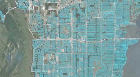
Through solutions based on the analysis of satellite photos and machine learning models, it is possible to optimize the process of identifying the best land uses and analyze the areas where a construction project will be developed with a high level of detail, in order to find the optimal location and minimize investment risks. The […]
New Products and Brands: How to Determine their Acceptance?

Using advanced technology applied to the extraction and processing of large volumes of data, it is possible to obtain the necessary information to evaluate whether a new product, service or brand will be accepted when it begins to compete in a specific market. Companies that intend to compete in a new market always ask themselves […]
Satellite Images for Decision Making
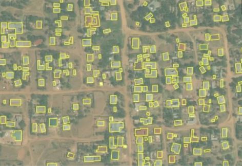
With the technologies available it is possible to use satellite photos to detect types of surfaces and roofs, objects, land use and variance in farmland, and then analyze the results and transform them into useful data for business decision making. In the past, it was possible to establish whether an area was industrial, commercial, residential […]
Big Data Vs. Traditional Surveys
Does it make sense to keep doing surveys to evaluate, for example, the ranking of a brand, when all the real, honest, and unbiased information can be inferred from people’s behavior on the Internet? “… Traditionally, when teachers or business people needed data, they commissioned surveys. They obtained data in an orderly fashion, either in […]