Geospatial data or geodata is essential in business analytics, providing a multi-dimensional perspective to understand and engage with the world around us. Geospatial data consists of information with a geographic location component, describing objects, events, or phenomena in a specific location on Earth.
In this article we will cover the following topics:
Understanding the main attributes of geospatial data
Geospatial data is unique due to its comprehensive nature, which includes three core components: location, attribute, and time.
- Location: The location usually works in terms of latitude and longitude coordinates.
- Attribute: Attribute information describes the characteristics of objects or events, such as the height of a building or the speed of a moving car.
- Time: Temporal data provides a chronological context. Therefore, geospatial data offers a complete picture, whether you are tracking the movement of a vehicle over time or mapping out static locations like office buildings, hospitals, or supermarkets.
Also, versatility plays a crucial aspect in geodata. Why? Well, it can be static or dynamic. For example, the location of a landmark is static—it doesn’t change over time. On the other hand, the path of a moving vehicle is dynamic, changing its location over time. This flexibility makes it immensely useful for vast applications.
The two types of geospatial data
There are two main types of Geospatial data: Vector and Raster.
Vector data: It represents features in the real world as points, lines, and polygons. Each part has a set of attributes, such as its name, type, and location.
Vector data often represents discrete features like buildings, roads, and rivers.
Raster data: It represents the Earth’s surface as a grid of cells. Each cell contains a value representing the property of interest, such as elevation, land cover, or vegetation.
Raster data often represents continuous features, such as land cover or elevation.

What is geospatial analytics?
Geospatial analytics involves analyzing insights with spatial or geographic components such as GPS coordinates, street addresses, zip codes, and satellite imagery insights.
Geospatial analytics can answer questions about the distribution of things in space, the relationships between different locations, and the changes that occur over time.
Also, geospatial analytics add timing and location to traditional types of data. How? By combining existing information with geographic information system (GIS) data. By adding this spatial context, geospatial analytics can help to reveal patterns and trends that would not be visible in the data alone.
“The global market of Geospatial Analytics is projected to grow upt to US 141.9 billion by 2028.”
MarketsandMarkets
Furthermore, geospatial analytics is key when building data visualizations, which can take many forms, such as maps, graphs, and charts. This is how organizations can understand their data more intuitively and identify patterns and trends that might not be obvious.
Finally, data scientists use geospatial analytics to make predictions. This is done by identifying patterns and trends in the data and then using those patterns to forecast future events. For example, real estate developers use it to predict where new corporate buildings should be located.
Benefits of using Geospatial Data Analytics
In the modern business landscape, the utility of geospatial analytics does not reduce to specific sectors. It enhances areas like market research, supply chain management, and risk assessment from retail to agriculture.
“Although geospatial analysis, as empowered by GIS, was originally used in connection with life sciences such as geology, ecology and epidemiology, its use has since become manifest throughout most industries.”
IBM
Competitive intelligence
Geospatial data enhances competitive intelligence by tracking crucial activities from your competitors.
For example, a company can use it to track logistic behavior and relationships with suppliers and distributors.
Learn more about: Competitive Intelligence with a Geolocation Approach
Geospatial predictive analytics
Predictive geospatial analytics uses geodata in predictive modeling. With this, organizations can improve decision-making by providing insights that can be used to make informed decisions.
For example, a company can use geodata to predict the demand for a new product by considering the location of potential customers, the demographics of the area, and the competition.
Also, geospatial data can improve the accuracy of predictive models by providing additional context about the data. For example, a company can use geospatial analytics to predict where customers will likely shop by considering their location, demographics, and past purchase history.
Investment research
Investors use geodata to research potential areas with exciting uncovered opportunities.
For example, a company can use geospatial data to identify areas that are experiencing population growth or economic development, which can be good indicators of potential investment opportunities.
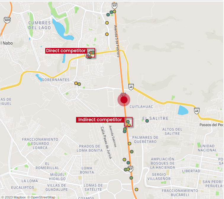
Trade area analysis
Geospatial data helps analyze trade areas (Both industrial and commercial). Geodata analytics helps decision-makers understand customer behavior and economic activity within a specific geographic area.
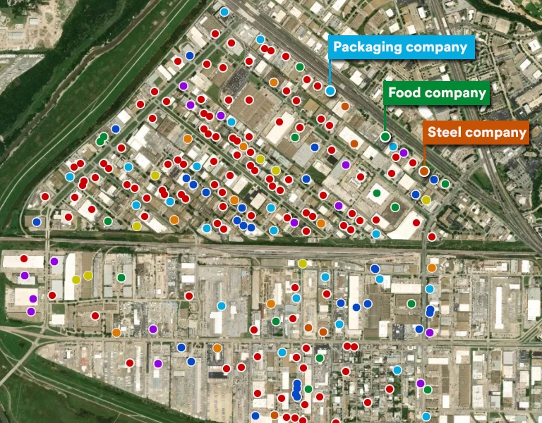
A company can use Trade Area Analysis to strategically plan for expansion by determining optimal locations for new offices, branches, production plants, subsidiaries, and warehouses.
Risk assessment
Geospatial insights are significant in today’s risk assessment and site selection processes.
For example, an industrial company can use geospatial insights to assess the risk of flooding in a particular area before deciding to build a new facility there.
Geolocation data and Big Data has also transformed risk assessment in Supply Chain Management by providing visual insights into potential risks, supplier analysis and disruption risks.
Supply chain management
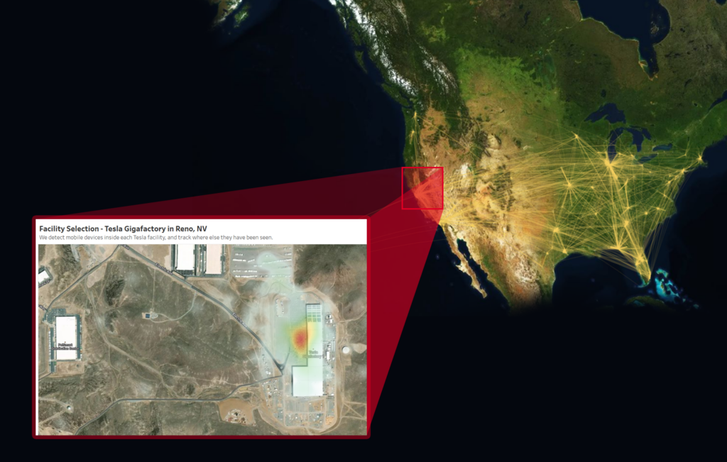
Geospatial analytics improves supply chain management by tracking the movement of goods and materials more precisely.
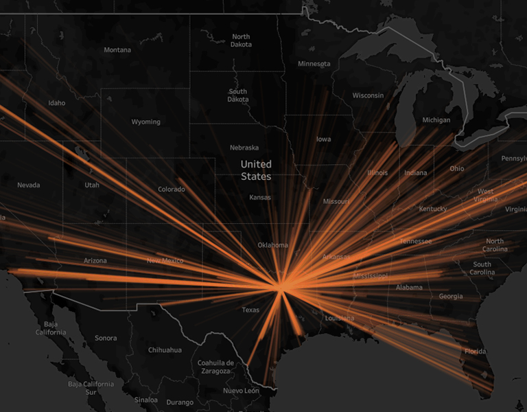
For example, a company can use geodata to track trucks and shipment movement, which can help them improve operative efficiency while reducing possible risks.
Learn more about our Supply Chain Mapping Tools
Where to get geospatial data?
The volume and variety of geospatial data is immense. It can be sourced from multiple sources, such as:
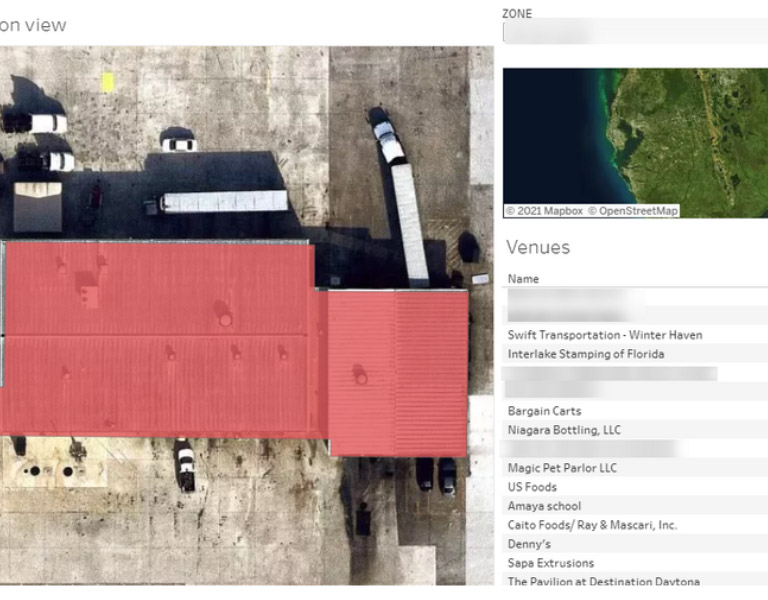
Points of interest (POIs): POIs are features on the Earth’s surface that people may want to visit, such as businesses, restaurants, parks, and schools.
Property: Property data includes information on land parcels, such as the owner, address, and size. This data can be used to track land use, assess property taxes, and plan development.
Mobility: Mobility data includes GPS information on how people move around, such as transportation networks, traffic patterns, and pedestrian activity. This data is helpful to plan transportation infrastructure, improve traffic flow, and make cities more walkable.
Demographics: Demographic data includes information on the population, such as age, gender, and income. This data helps understand the needs of a community, target marketing campaigns, and allocate resources.
Imagery: Imagery data includes information on the Earth’s surface as captured by satellites, airplanes, or drones. This data can be used to create maps, track changes over time, and identify features of interest.
Main challenges when using geospatial data
Even though geospatial data can be a game-changer in most companies, it can also be challenging due to its volume, heterogeneity, quality, complexity, cost, security, and privacy concerns.
Volume: Datasets can be massive, making it difficult to store and process. This issue can strain storage resources and make finding the data you need difficult.
Heterogeneity: Geodata can come in many different formats and standards, making it challenging to combine and analyze. For example, sensor data may come in different formats depending on the source. This can make it difficult to compare and integrate data from several sources.
Quality: Geospatial information can be inaccurate or incomplete, leading to wrong results. This can make it difficult to trust the results of geospatial analysis.
Complexity: Geospatial analysis can be complex and require specialized knowledge. For example, it may require knowledge of spatial statistics, GIS software, and data visualization techniques.
Cost: Without the proper sources, geodata can be expensive to collect, process, and analyze.
Data security and privacy: Geo sources can raise concerns about user security and privacy.
The importance of working with data experts
Working with a specialized data company can be beneficial to overcome the challenges of geospatial data.
At PREDIK Data-Driven, we have the expertise, resources, scalability, security, and privacy measures to help you collect, process, analyze, and interpret geodata correctly. Our specialized methodology brings you the right data methods and analytics for your specific needs and business objectives.